
Discover Peterborough · Bronze Age Peterborough
Flag Fen.
Where the Bronze Age survived.
Water · Timber · Bronze · Ritual · Survival
Three thousand years ago, people drove thousands of timbers into the wetlands east of Peterborough, creating a monumental route across a changing landscape. They repaired it for centuries, walked it, deposited weapons and jewellery beside it, and left behind one of the most extraordinary prehistoric sites in Britain.
Peterborough · c.1300 BC
A monument built into a changing wetland
Not a village.Not simply a bridge.
Flag Fen is one of the most important prehistoric wetland sites in Britain because it preserves something archaeology usually loses: timber.
Across the low-lying basin east of Peterborough, Bronze Age communities constructed a timber alignment more than a kilometre long. It linked the higher gravel terraces of Fengate in the west with Northey in the east and incorporated walkways, rows of upright posts and a large timber complex commonly known as the platform.
The structure was not built once and abandoned. Dendrochronology and excavation show repeated construction, repair and alteration over roughly four centuries. Historic England places the main sequence from the Middle Bronze Age into the Late Bronze Age, with use continuing into the Early Iron Age.
People crossed it, maintained it and deliberately placed bronze weapons, jewellery and other objects into the waters beside it. Many had been broken or disabled before deposition. The combination of engineering, ritual and extraordinary preservation makes Flag Fen unique.
“At Flag Fen, the Bronze Age did not disappear. It sank into waterlogged peat and waited.
The Landscape Before Flag Fen
Fengate · Northey · the Flag Fen Basin
A dry landscapebecomes a wet one.
The monument only makes sense when the landscape is allowed to change.
Earlier prehistoric communities farmed comparatively dry ground around the basin. Excavation at Fengate revealed extensive Bronze Age field systems, droveways, yards and paddocks used for managing livestock. The basin itself gradually became wetter as water tables rose and peat began to form.
Historic England records peat formation in the deepest part of the basin from roughly 2030–1680 BC. By about 1300 BC, seasonal flooding was affecting lower land on the fen edge. Fields were abandoned and remade higher on the gravel terraces.
Water was not simply an obstacle. It created a new kind of landscape: reeds, channels, grazing, pools and wet ground separating communities on the higher margins. Flag Fen emerged from that changing relationship between people and water.
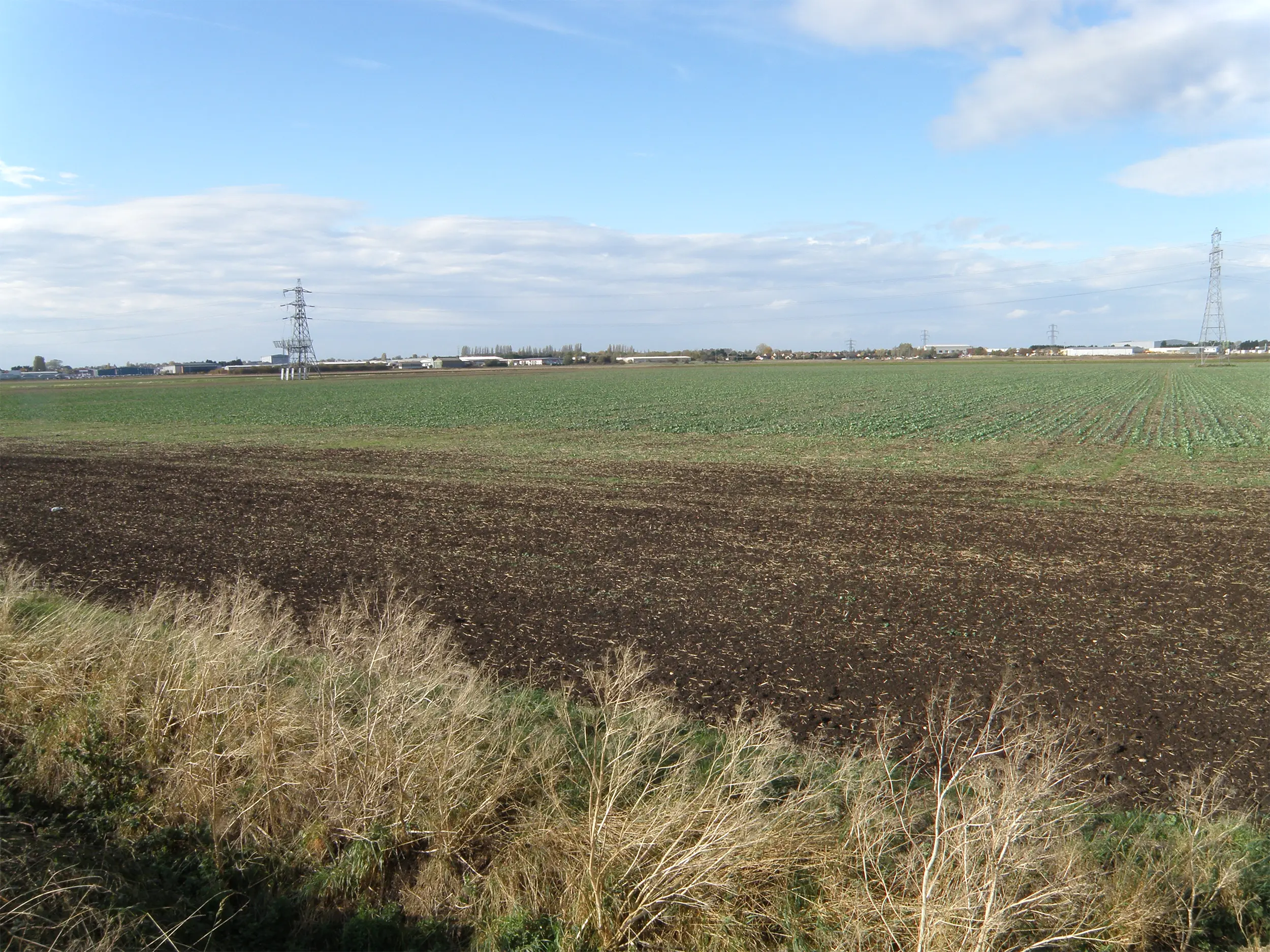
Fengate
The dryland half of the story
Fields, cattleand organised movement.
Before archaeologists understood Flag Fen, decades of work at Fengate had already revealed an unusually organised Bronze Age landscape.
Excavations from the 1960s and 1970s identified ditched fields, long droveways, enclosures and livestock-management areas. Francis Pryor’s synthesis interpreted parts of this system as communal spaces connected with cattle movement, exchange and seasonal gathering.
One major droveway pointed directly towards the wetland. The timber alignment at Flag Fen continued that axis across the basin towards Northey. The monument therefore did not sit in isolation: it physically connected two inhabited landscapes.
The Causeway
A kilometre of timber across the wetland
Thousands of pieces of wood.One monumental line.
The surviving alignment is one of the great feats of prehistoric timber engineering in Britain.
The earliest major phase
The first phase included two principal post rows, mainly alder, with horizontal timbers consolidating the wet surface and a narrow walkway.
The enduring spine
Historic England records Row 3 as the only major line maintained throughout the long life of the alignment.
Expansion and renewal
Later phases added denser post lines, widened the structure and altered circulation through the monument.
Trampled, repaired, gritted
Successive walking surfaces show wear. Sand and gravel were laid in places to improve grip on wet and slippery timber.
How It Grew
A monument maintained for generations
Flag Fen was never finished.
Construction begins
The first major timber lines and walkways are established as the basin becomes increasingly wet.
A period of stability
The first arrangement remains in use for generations.
Renewal and enlargement
The structure is rebuilt and expanded with additional post rows and changing routes.
Building stops
Major maintenance ceases, although the route and place continue to be used into the Early Iron Age.
The Platform
House? Meeting place? Shrine? Something more complex?
The most famous part of Flag Fenis also the hardest to explain.
Early interpretations treated the timber platform as a domestic structure. Later research made that explanation increasingly difficult to sustain.
The so-called platform was a dense and complicated mass of horizontal and upright timbers. It may not have formed one continuous solid floor. Openings and pools appear to have been deliberately incorporated into its layout.
Fragments of adult human bone were recovered from the platform. One interpretation is that parts of it may have been used in mortuary rites, perhaps including the exposure or laying out of bodies. That remains a hypothesis, not a certainty.
The safest conclusion is that the platform was a long-lived, changing structure with social and ceremonial functions that cannot be reduced to a single modern label.
Bronze in the Water
Weapons, ornaments and deliberate deposition
Why throw valuable objectsinto a fen?
The metalwork transformed interpretation of the site.
Weapons, tools, ornaments and personal objects were deposited beside the timber structure. Most were bronze, but the assemblage also includes iron, tin or lead and a single gold object. Swords, spearheads, daggers and jewellery appear repeatedly.
Historic England notes that many objects seem to have been deliberately broken or disabled. Their locations were not random: particular kinds of material clustered in particular zones, and the great majority of offerings were placed south of the post alignment or carefully within its timbers.
This pattern is one reason Flag Fen became famous as a possible Bronze Age ritual centre. Yet modern work in the wider basin, especially at Must Farm, has complicated any simple division between “ritual” wetland and “everyday” settlement.
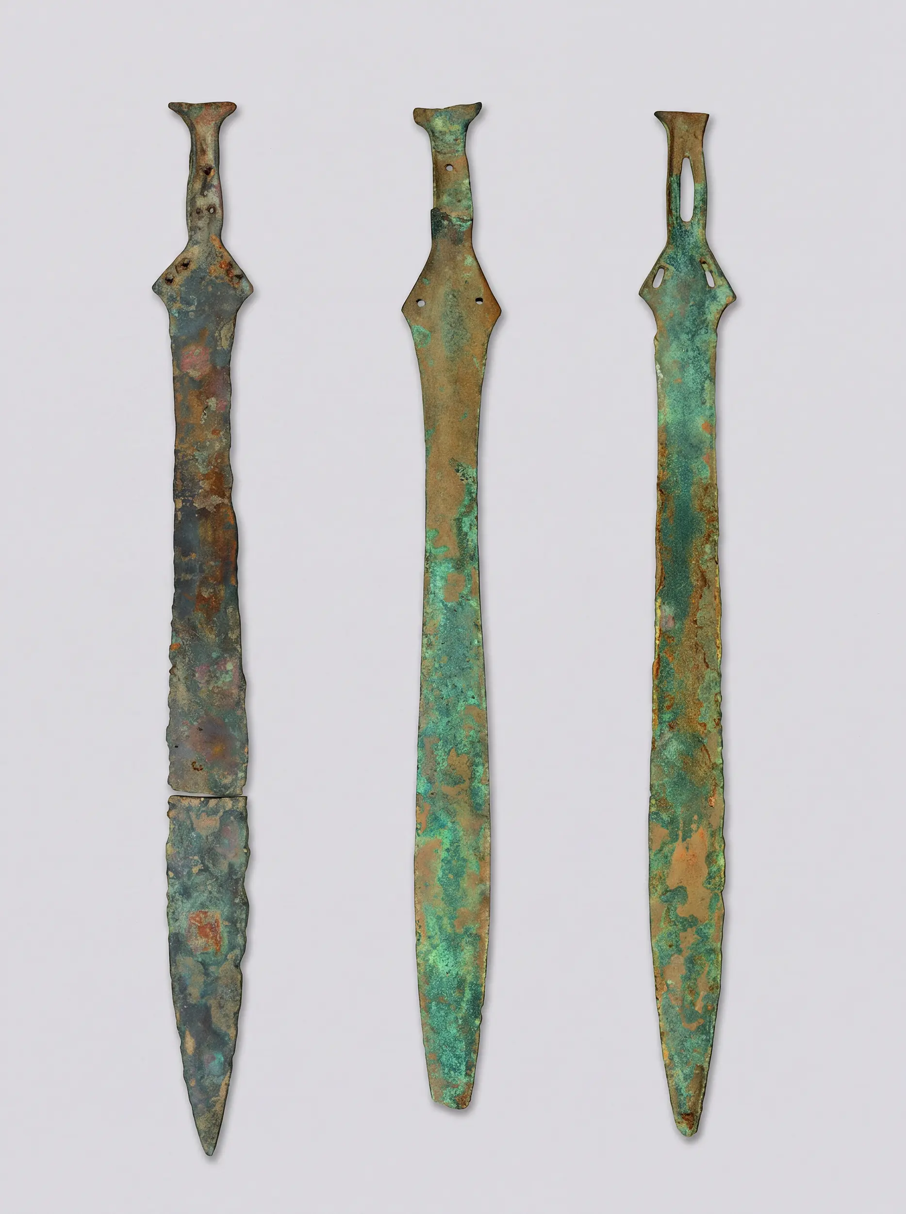
Deposition
Patterns, not rubbish
Broken. Placed. Remembered.
Swords, spears and daggers
Prestigious martial objects entered the waters alongside the monument.
Jewellery and ornaments
Items associated with bodies and identity were also deliberately deposited.
Objects made unusable
Many pieces appear to have been deliberately broken, bent or disabled before deposition.
Not randomly scattered
Different classes of object cluster in particular areas of the alignment.
A preferred direction
Most offerings occurred to the south of the alignment or within the timbers themselves.
Ritual continuity
Deliberate deposition continued through the Middle and Late Bronze Age and into the Iron Age.
Woodworking
Archaeology at tree-ring scale
The builders lefttheir decisions in the wood.
Waterlogged preservation allows archaeologists to study prehistoric carpentry at a level normally impossible on dryland sites.
Alder was heavily used in the early phase, with increasing use of oak in later rebuilding. Tool marks, joints, trimming and the form of roundwood reveal how trees were selected and worked.
Dendrochronology helps place construction phases in sequence and demonstrates that the structure was renewed over generations rather than created in a single episode.
The surviving timbers are therefore both architecture and archive: each stake records woodland choice, labour, technology and repeated investment in the same place.
1982
Discovery in a drainage ditch
The monument reappearsbecause Peterborough was being investigated.
Flag Fen was not found by treasure hunting. It emerged from decades of systematic archaeology around a rapidly developing city.
Antiquarian recording at Fengate began in the early twentieth century. Peterborough’s New Town expansion and industrial development then triggered major rescue excavation from the late 1960s onwards.
During the Fenland Dyke Survey in 1982, archaeologists encountered timbers in the waterlogged basin. Excavations from 1983 onwards revealed that they belonged to something far larger and stranger than expected.
The discovery transformed understanding of Bronze Age Peterborough and eventually created one of Britain’s best-known wetland archaeology projects.
The Archaeology Story
A century of investigation
Flag Fen was discovered in stages.
George Wyman Abbott
Finds from gravel workings at Fengate begin to reveal the archaeological density of Peterborough’s eastern edge.
Rescue archaeology
Development pressure and New Town growth trigger systematic excavation and recording.
The Fengate Project
Major excavation exposes Bronze Age field systems, droveways and settlement evidence.
Timbers found
The Fenland Dyke Survey encounters the waterlogged remains later identified as part of the Flag Fen monument.
Flag Fen excavated
Successive campaigns investigate the platform, alignment, environment, wood and artefact deposition.
Condition reassessed
New work examines how much archaeology survives and how changing groundwater threatens it.
The Wider Flag Fen Basin
Must Farm changes the picture
Flag Fen was notalone in the wetlands.
Discoveries at Must Farm have transformed how archaeologists imagine life in the same prehistoric basin.
Excavations at Must Farm revealed an exceptionally preserved Late Bronze Age settlement built over a watercourse, along with logboats, fish traps, weirs, textiles, pottery, tools and whole household assemblages. It lies within the same changing wetland system.
Cambridge Archaeological Unit argues that the intensity of activity across the basin makes older interpretations of Flag Fen as an isolated “cult centre” too simple. Wetland ritual and everyday life may have been much more closely entangled.
The result is a richer picture: communities farming the dry margins, moving across water, living above channels, fishing, travelling by logboat and repeatedly investing meaning in wet places.
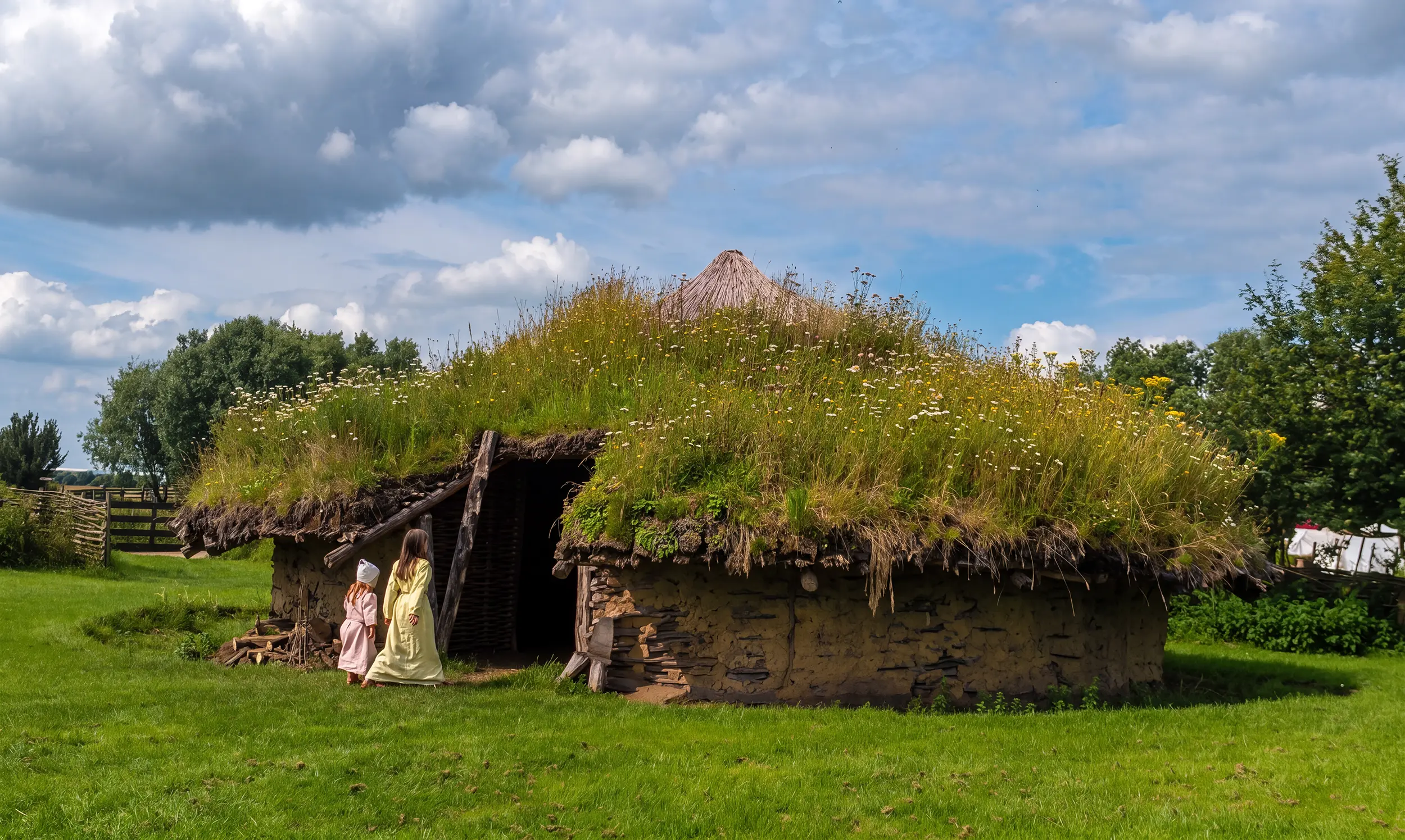
Imagining Bronze Age Life
What reconstruction can — and cannot — do
Archaeology gives us evidence.Reconstruction gives it scale.
The most spectacular remains at Flag Fen are timber foundations and waterlogged deposits, not intact houses standing above ground.
Reconstructed roundhouses help visitors understand Bronze Age materials, domestic space, roofing, smoke, light and craft. But they should not be confused with a claim that the famous platform was simply a settlement of reconstructed houses.
The archaeological value of Flag Fen lies precisely in the questions it leaves open. Good interpretation should make the uncertainty visible rather than replacing it with a neat story.
The Landscape Moves On
Iron Age and Roman Flag Fen
The Bronze Age monument vanished.Its line may not have been forgotten.
By the Roman period, peat and alluvium had buried the timber monument.
Historic England notes that the old alignment may still have remained visible as a subtle raised feature. The later Roman Fen Causeway crossed the basin on a broadly comparable route, connecting the Roman town of Durobrivae west of Peterborough towards Denver and the Fenland road network.
Nearby cropmarks include enclosures and a possible Romano-Celtic temple. Flag Fen therefore sits within a landscape used and reorganised repeatedly for thousands of years.
The Paradox of Preservation
Water saved Flag Fen. Drainage can destroy it.
Three thousand years underwater.One modern conservation problem.
Wood survives in waterlogged ground because low-oxygen conditions suppress the organisms that normally break it down.
The same archaeology becomes vulnerable when groundwater falls. Drainage exposes buried organic material to oxygen, allowing decay, shrinkage and structural collapse.
Historic England has listed the monument on the Heritage at Risk Register since 2012. Its 2021 condition assessment found significant concern over degradation, while hydrological modelling identified local artificial drainage as a crucial control on groundwater levels.
Conserving Flag Fen therefore means conserving not only objects but the wet conditions that made their survival possible.
Why Flag Fen Matters
What the site changes about British prehistory
Six reasons this place is exceptional.
Scale
A timber alignment extending for more than a kilometre across a wetland basin.
Longevity
Construction and maintenance continued for roughly four centuries.
Organic survival
Waterlogged conditions preserved timbers and other materials usually lost to archaeology.
Ritual evidence
Structured deposition of weapons, jewellery and other objects records repeated ceremonial behaviour.
Landscape context
Fengate, Northey and Must Farm allow the monument to be understood as part of a densely used prehistoric basin.
Research value
Flag Fen remains a living scientific problem, from woodworking and chronology to hydrology and conservation.
The Long View
Flag Fen in 16 moments
A landscape transformed.
A drier basin
Communities occupy and use a landscape before major peat formation.
Peat begins forming
The deepest parts of the basin become increasingly waterlogged.
Causeway construction
Timber rows and walkways begin crossing the basin between Fengate and Northey.
Use and deposition
Communities walk the route and place objects beside and within the structure.
Major renewal
The alignment is enlarged and reorganised.
Construction ends
The monument remains in use into the Early Iron Age.
Fen Causeway
A Roman route crosses the now buried prehistoric landscape.
Fengate antiquarian discoveries
George Wyman Abbott records finds from local gravel extraction.
Rescue excavation
Peterborough’s development triggers intensive archaeological work.
Fengate Project
Bronze Age fields and droveways are mapped and excavated.
Flag Fen timbers discovered
The Fenland Dyke Survey encounters the waterlogged structure.
Major excavation
Platform, post alignment, environment, metalwork and wood are studied in detail.
Preservation infrastructure
A visitor centre and artificial mere are established as part of efforts to keep the archaeology waterlogged.
Flag Fen Basin monograph
Francis Pryor’s English Heritage synthesis brings decades of research together.
Scheduled and At Risk
The monument receives formal scheduling; waterlogged remains are recognised as vulnerable.
Condition reassessed
New excavation and hydrological work document continuing threats to buried timber.
Walk Into Prehistory
Flag Fen Archaeological Park
The monument survivesbecause the landscape survived with it.
The power of visiting Flag Fen is not that a Bronze Age monument stands intact above ground. It is that the actual prehistoric structure still survives below and within the wetland landscape.
Read the ground
Understand the relationship between dry gravel, wet basin and the line of the causeway.
See preserved timber
Waterlogged wood makes prehistoric engineering tangible in a way dryland sites rarely can.
Walk the reconstruction
Use the reconstructed causeway to appreciate the scale and physical experience of crossing wet ground.
Meet the metalwork
The artefacts explain why the monument became central to debates about Bronze Age ritual.
Think beyond the site
Connect Flag Fen with Fengate, Northey, Must Farm and the wider prehistoric basin.
Look at the water
The water table is not scenery. It is part of the archaeology’s survival system.
Continue the Story
Flag Fen connects deep prehistory with Peterborough’s wider history
Go deeper.
Research & Further Reading
Built from archaeological evidence.
This article intentionally does not use the Flag Fen visitor website as a research source. Its factual framework is drawn from statutory designation, excavation reports, peer-reviewed archaeological research and work on the wider Flag Fen Basin.
- Historic England: Flag Fen Bronze Age post alignment, timber platform and associated landscape — Scheduled Monument
- Historic England Research Report 66/2023: condition and preservation of the Flag Fen archaeological remains
- Historic England Research Report 108/2015: Hydrological Modelling of the Flag Fen Archaeological Site and Wider Landscape
- Francis Pryor, The Flag Fen Basin: Archaeology and Environment of a Fenland Landscape, English Heritage, 2001
- Francis Pryor, “Current research at Flag Fen, Peterborough”, Antiquity
- Maisie Taylor, “Flag Fen: the wood”, Antiquity
- David Coombs, “Flag Fen platform and Fengate Power Station post alignment — the metalwork”, Antiquity
- Paul Halstead & Ellen Cameron, “Bone remains from Flag Fen platform and Fengate Power Station post alignment”, Antiquity
- Historic England / Cambridge Archaeological Unit: Must Farm and the changing interpretation of the Flag Fen Basin
Image Credits
Photography & licensing.
Third-party and licensed images used on this page are credited below. Discover Peterborough-owned photography does not require an external licence credit. Cropping, resizing and WebP conversion do not remove the underlying licence conditions of externally sourced images.
- Flag Fen landscape / hero, opening image, discovery section and final visitor section
Photograph by Terry Harris / Discover Peterborough. Used with permission. - Flag Fen basin landscape
Michael Trolove / Geograph Britain and Ireland / Wikimedia Commons. Creative Commons Attribution-ShareAlike 2.0. - Flag Fen trackway / wooden-post markers
Midnightblueowl / Wikimedia Commons. Creative Commons Attribution-ShareAlike 3.0. - Reconstructed Bronze Age roundhouse at Flag Fen
Midnightblueowl / Wikimedia Commons. Creative Commons Attribution-ShareAlike 3.0.
Discover Peterborough
Before the Romans.Before the Cathedral. Before the city.
Flag Fen belongs to a Peterborough landscape that people were organising, crossing and investing with meaning more than three thousand years ago. The city’s story does not begin with streets or stone. It begins in fields, water, timber and peat.
Continue through Peterborough history →